
Travel: Tracking the Ganga
A river’s avatars
In which I undertake a journey to gaze at the Ganga, all the way up to Badrinath.
IT is a somewhat surreal situation.
I’m sitting in a small room 3,133 metres above sea level, literally in the lap of snow-capped mountains. A voice, speaking in fluent Hindi laced with a hill patois, is telling me all about GPS.
Only, it’s no techie speaking, it’s the young head priest of the Badrinath temple in the upper reaches of the Garhwal Himalayas, who is elucidating on man’s position vis-à-vis God, indeed a unique view of the global positioning system. To further confound the situation, the priest, or Raval as he is known hereabouts, is a Namboodiri from the Kannur region of Kerala.
The Raval is troubled by the fact that he doesn’t see too many young people coming to Badrinath. This surprises me… forget the religious angle, the trip is a naturalist’s dream come true.
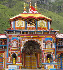
Badrinath: The remote, craggy Himadri mountains looming steeply on all sides, the roaring Ganga in her many avatars flowing many thousand feet below, eagles soaring in the brilliantly blue skies above and, at destination’s end, a brightly painted temple with the magnificent Neelkanth mountain rearing up behind it.
Given that hordes head for the treks to Hemkund Sahib and the Valley of Flowers, just 20 km short of Badrinath, it is indeed mystifying why they do not complete the journey to this spectacular terrain.

Worth a ride
I went for the ride, literally, as it were. The road, cut out from the mountain, put me forcibly in mind of tracks I had once traversed in another part of the Himalayas, beyond Leh. These are tracks that put a new spin on the term “bone-jarring”.
Hardly does the Border Roads Organisation (BRO), which maintains these roads, rectify one patch than another of the all-too-frequent landslides happen, and take away another chunk of road.
It’s an arduous 12-hour ride from Dehradun, about 340 km away, but what a trip! Just 43 km out of Doon, we catch the Ganga at Rishikesh. She’s a muddy brown in this season. It’s early in the morning and a thin mist hangs over the temple town.
Our breakfast stop is famous for its river rafting facilities, Kaudiyala. Here, the Ganga flows swiftly, crashing into rocks and boulders, throwing up white spray. The hills that hedge Kaudiyala are still gentle in mien.
Some distance ahead is Devprayag, where the Bhagirathi and the Alaknanda come together and become the Ganga that flows down into the plains.
We pass Srinagar, home of the Garhwal University. The hills are a constant, comforting presence around the river till Chamoli, after which they become looming mountains. The slopes are covered with rust and yellow coloured foliage, spiked occasionally with a deep red; the colours of autumn in the Garhwal Himalayas.
Next we head to Rudraprayag where a burbling Mandakini meets the Alaknanda. This is our lunch stop, though I’m more occupied with staring at the sludge- coloured Alaknanda mingling with the uncertain green of the Mandakini, than eating the basic fare on offer at the Garhwal Mandal Vikas Nigam guesthouse: roti, daal, sabji and a dish of rasgollas as dessert.
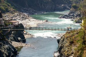
At this point, the roads are still veering between fair to indifferent; the downslide, if you’ll pardon the pun, begins after Gauchar. The ravines, crevices and gorges are deep; oftentimes, we come upon brilliant green patches of paddy terraces and suspension bridges that hang, a feat of engineering, above the tumultuous river.
We pass Karnaprayag where the Pindar blends into the Alaknanda and move towards Nandaprayag, where it’s the turn of the Nandakini to combine with the ever-constant Alaknanda.
After Chamoli, the landscape changes subtly but startlingly; the mountains start to loom, the hamlet of Gopeshwar can be seen hugging the mountainside, slim but fierce waterfalls appear. The Alaknanda, too, changes colour to a faint aquamarine, and seems cleanest at this point.
Moving boulders have cut deep swathes into the sides of the ranges. Closer to Badrinath, we notice fields planted with a red flower; it’s madua, our competent driver Bakuni informs us, a local millet-like crop.
We pass Pipalkoti and now it’s pines that spring up, sometimes from rocky outcrops on the mountain slopes. At Helang the road turns positively wicked. We wait while the occasional rock blasting and clearing goes on; it’s not an impatient wait, there’s much to see and absorb.

Up there in the clouds
Signs inform us that we are in the Valley of the Gods; that this range is part of the Nanda Devi Biosphere Reserve. By now, I am getting the feeling that it’s just us and the mountains, the river is almost forgotten, the road loops and loops again back on itself.
Next comes Joshimath where the Adi Shankaracharya is said to have attained enlightenment and where Lord Badrinath comes down for his winter hibernation, as the utsav murti.
Next up is Vishnuprayag where the Dhauli Ganga joins the Alaknanda, and then, Pandukeshwar, at 1,955 metres above sea level; at Hanumanchatti, the Alaknanda receives the Kairon Ganga born from the Neelkanth peaks.
And at Govindghat, the line of trekkers veer off for the Valley of Flowers.
At Badrinath itself, it’s an exultant river, leaping and bounding with joy, a blueish-green Alaknanda, with a sulphur spring just at the feet of the Lord, bubbling and hissing. Green mountain meadows lie all around and I glimpse a glacier in the trough of a mountain; the air is suddenly thin, infused with a sharp bite.
Crowds mill in the courtyard of the small temple which holds a swayambuidol of Vishnu, apparently discovered in a lake by the Adi Shankaracharya and installed at its present location.
This being devbhoomi, the gods do not have to be invoked at the pujas, they already reside here and can be called forth. As one comes out of the temple, one’s eyes catch the mountains looming in a semi-circle, the Nar and Narayan peaks, the jewel in this crown being the lofty Neelkanth at 6,597 metres, and the magic starts up all over again.

Must-do journey
Ahead of the Badrinath Valley lies Mana, the last hamlet on the Indo-Chinese border, with the cave of Rishi Vyas who is supposed to have dictated the Mahabharata to Lord Ganesha here; some two km ahead, a silvery skein, the legendary Saraswati, makes its appearance. The mule paths are narrow, lightly covered with dry moss. Here and there, water gleams on glistening black rock.
The return journey is one of introspection. And when one loses the river after Rishikesh, the eyes ache for one more glimpse of it. Whether for the salvation of the soul or for the thrill of adventure, this is a journey every one must make, at least once.
http://www.hindu.com/mag/2006/11/19/stories/2006111900320800.htm
This ran in THE HINDU of 19 Nov 2006.
Related Links:
Travel: Dhanaulti, Uttarakhand
Travel: Sun Temple in Katarmal
Travel: Jageshwar Temple, Kumaon
![]() Sheila Kumar • February 14, 2013
Sheila Kumar • February 14, 2013